
"I went to the woods because I wished to live deliberately."
— Henry David Thoreau
Travel Log
Notes from the Road


April 19, 2009
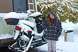
We're off! Drive across the county line heading north at a blazing 38 miles per hour. 54,512 miles on the odometer.
It's 7:45pm and we're on our way! Look out America, here we come.
April 21, 2009
Lunch in the Goethe State Forest. This is really too nice of a place to put a
nuke plant.
Picked up some new shoes and
gave the Spaceship a bath in Perry, Florida. On a dark and stormy night (!) we entered the Apalachicola
National Forest.
April 22, 2009
Woke up to a chill in the air and a view of slightly fire-crispy woods. The steam rising off the lake in whorls of dark
and light. As we slept, chirruping gators called to one another in the night. It’s sunrise in the Clear Lake Wilderness.  Magical.
April 23, 2009
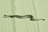
Leaving the tiny frogs and tadpoles of Apalachicola behind, we crossed paths with a mesmerizing, side-winding
rattlesnake on the way out. Do some lunch and Spaceship maintenance at Coe Landing.
April 24, 2009
GEORGIA! Turtles, gators, coots, mosquitoes.
April 25, 2009
We’re in skink territory. They’re great fun. Also, a pair of sparrows keep trying to build a home in the scooter
and on the roof. A turtle is digging out her own nest on our campsite. What an honor, their trust.
April 28, 2009
Leaving Faceville Landing and the coots behind, but we won’t miss the mosquitoes. Relieved the Spaceship of its
blackwater in Bainbridge, GA, at the Earle May Boat Basin, where we stumbled across a strange sort of petting zoo with goats,
emus(?) and a donkey. Spent the night at an exceedingly well-lit Wal-Mart.
April 29, 2009
Met the very nice Strickland family on their farm outside Colquitt, Georgia. Picked up some farm-fresh goodies.
Yum. Drove onward toward the new campsite. Saw lots of cardinals, plus a coyote straddling a train track, watching us
attentively as we drove past. A beautiful, clear day. Drove a leisurely 35mph down country roads and didn’t see another car.
We’re at a new campground now at Coheelee Creek, Nuclear power plant warning signs a little too omnipresent for our taste.
Very treesy and secluded, now trying to get an internet signal.
April 30, 2009
Walked from our campsite to the “southernmost covered bridge.” Graffiti-adorned by the local teens, but over a sweet
little creek with a waterfall. Wrens, wrens, wrens. Our tiny bird friends
made a home in the scooter 3 times. We stuffed
a few plastic bags in there, in hopes of discouraging them. They’ve been at the windows, on the roof, even under the
vehicle this morning. We can learn from their persistence — though what we should learn, exactly, we’re not sure yet.
They are very, very cute, peering in at the window. Their bellies are sort of tinted yellow and they have a brownish
stripe over their eyes.

May 1, 2009
Found a nice free campground at Rood Creek to spend the night. We’d stay longer, but we’re eager to get to the Appalachians.
May 3, 2009
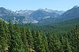
We spent a couple nights in Alabama’s Talladega National Forest, the foothills of the Appalachians, and hiked the Cheaha Wilderness.
It was nighttime when we arrived, and from a distance, we watched a lightning storm hover over the soft dome of Mt. Cheaha.
Faith’s favorite spot here was a collection of waterfalls where tiny bugs with very gauzy wings alighted above the stream,
floating up and away, falling like rain. Or they might have been fairies. :-)
May 4, 2009
HOORAY -- We escaped Jacksonville, AL, just about 10 minutes ahead of a tornado yesterday. Thankfully we have internet,
so we can track bad weather and just drive away from it. A change of itinerary was required, though. No Sispey Wilderness. :(
May 5, 2009
We woke up this morning just outside of Aberdeen, Mississippi. We’re not far from the place where Drew’s grandfather grew up,
and we’re looking forward to scootering over there in the next few days to see what we can see.
May 6, 2009
Folks around here are friendly and love to chat. Found a great radio station.
May 8, 2009
Scootered to Egypt, the childhood home of Drew’s grandpa, Dave. Small and scantily populated, it’s not so much a town as it is
a collection of houses and memories. While we were there, we met Eddie and Willy who make furniture in a great half-cylinder
of a warehouse that runs along Egypt’s railroad tracks. They were patient with our questions and our out-of-town quirks.
If you’re in the market for some nice hand-upholstered furniture, stop in and say hi.
May 12, 2009
Stayed the night at Lone Pine Campground in the St. Francis National Forest after leaving Mississippi.
Mississippi is lovely; the roads, mmm, not so much. We endured the rattling of the silverware and the
shuddering of the stove top with every seam in the road, approximately every twenty feet. Sigh.
Pitstop in Oxford yesterday — laundry and supply gathering. (New strategy: scout out the grocery store first,
then meal plan, then shop.) Last night, we rolled into Chewalla Lake after dark, so when we woke up today,
we had the pleasure of wondering what new view we’d enjoy when we opened the blinds. Fresh morning vistas
are one of the great benefits of this nomadic life. (On Wal-Mart mornings, we generally don’t open the blinds
until after we’ve had our serene little breakfast.) Today we regroup. Figure out where to go next and how to do it.
Enjoying the new growth on the Mississippi pines, stretching upward like pale, green candelabra.
May 16, 2009
As of this morning, it was still raining back in Alabama. Yesterday we drove the Ozarks — steep and beautiful roads.
Long, white beards appear to be popular among the local men. Towns possessing nothing more than a name and a church
seem to be the norm. This morning we woke up at Buffalo National River. (Who knew we had national rivers? So educational,
this life on the road!) Tonight we’re sleeping at the Arkansas visitor center near the AK/MO state line. We were planning
on stopping here for dinner, then pushing on to a camp site in Missouri, but this spot turned out to offer a free overnight
stay and we really were exhausted. Thanks to the RVer’s pal, Serindipidy, for these not-so-little gifts, much needed.
Looking forward to hiking. Hoping for an extended boondock starting sometime tomorrow.
May 17, 2009
A strange day. Woke up this morning at the Arkansas visitor center. Beautiful, cool weather. Feeling good.
Then the Spaceship wouldn’t start! Hung out until lunchtime, thinking the carburetor had flooded, tried again,
but didn’t fix until Drew tweaked the distributor cap. Finally, we were off again, driving through some rocky,
hilly terrain. Crossing the state line felt like a victory. Passed through Branson, MO, found out what Yakov Smirnov
has been up to. Arrived in Kissee Mills, where we planned to stay, and found out there had been so much flooding that
one of the campsite picnic tables was completely submerged. Got to the Hercules-Glades Wilderness of the
Mark Twain National Forest.
It’s been raining here, too. Crossed a strange water-road (I don’t even know how to describe it) and navigated puddles of uncertain
depth. Drove a really rough dirt road, uphill-uphill-uphill (we continue to be amazed by the capabilities of this vehicle)
and finally got to the trailhead, our new home for the next week or so. It’s a great spot though — we’ve got sun for solar,
southern sky for the internet, plus it’s bear habitat. A bunny stopped by for a visit this evening.
May 18, 2009
Just a note that if we ever pass through Arkansas again and still find ourselves curious about Ozark culture:
The Shiloh Museum of Ozark History.
May 21, 2009
Hiked the Coy Bald trail of the Hercules-Glades Wilderness yesterday.
Sadly, it was a little hard to relax, as
we’ve entered tick country — again. Blech. On the up-side, the most wondrous bunny comes around in the evenings,
hops, chews long blades of grass. (The long blades of grass, perhaps, accounting for the presence of the ticks).
May 22, 2009
Hiked the first couple of miles of the Falls trail in the
Hercules-Glades Wilderness. Faith had great fun at the
creek crossings and thinks she deserves much praise for her bravery, overcoming sketchy footing and the ever-present
possibility of a dunking in the chilly Missouri waters. Less fun were the ticks, who found their way into our socks,
our shoes, our underwear... We had a visit from TWO wondrous bunnies last night, our old rabbit friend and a new, smaller one.
May 23, 2009
This morning, departed the Hercules-Glades Wilderness. We’re finally getting our arrivals and departures down to a science.
We probably wouldn’t have gone up this particular road, with all its obstacles, had we not met a local who said she takes her
RV up there. There was a little part of us that, during the whole boondock, wondered...hmm...will we make it down again?
Drew, however, is an off-road driver par-excellence. With only the slightest strain showing on his face (!) he navigated
rocky pits (very rocky, very pitty), roads so slanty it seemed we might just roll the Spaceship, and of course, the strange
and lovely water road (previously and unsuccessfully described).
And so it is that we were on the road again, this time to Marionville, where we communed with a white squirrel.
Maybe we’ll look up their cousins counterparts in Kansas, who (we hear) are solid black.
May 25, 2009
Yesterday, as we were driving, a coyote came racing out of one field, crossed the road in front of us, and disappeared into
another field. This is the second one of the trip, and we can’t quite dismiss associations with the Trickster. Beautiful,
winding roads through the lower hills around Galena. Stocked up supplies in Joplin, and crossed into Kansas.
We were going to stay the night at an old rest stop in the original Route 66. No luck. Then, tried the city campground at
Baxter Springs. Really sweet...except for the pipe that spewed green water into the river.
Urg. Also, to stay at that campground,
you gave the local policeman (who is lurking around) your camping fee. Doesn’t that seem a little shady? BUT the third time was
the charm and we found a reasonably quiet, level spot alongside a feisty river. Spent the night without incident —
oh, actually that’s not true. We have a toilet leak. AARGH! We arrived in Chanute a few hours ago.
The carnies — either setting up or breaking down one their portable Farris wheels — are our neighbors, parked on the opposite side of the campground.
May 29, 2009
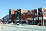
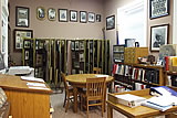
Getting to know Chanute, Kansas. We really enjoyed our visit to the public library, where they have a great
historical archive,
including a cool collection of photos. Faith was especially struck by (let’s see if we can explain this in a way that makes sense)
the sort of ’electric’ look of some of the kids’ eyes in the 1902 class photos — intense, very engaged. Also, we found a little spot
in the children’s section of the library, upstairs, a good place to read and hide and daydream. Also downtown, the Cardinal Drug Store
has an authentic soda fountain complete with antique tonic bottles and a very old-school cash register.
Drew treated himself to a butterscotch malted milkshake.
Happily, folks folks here keep on being friendly no matter how many times we show up. Elly showed us around the Chanute Art Gallery
— they’ve got some unusual pieces, definitely worth a visit. Sadly, we didn’t make it over to the Chanute Historical Museum.
(They’re only open weekends.) At the post office, a chatty little girl told Faith all about her rescue dog and invited us to
come over to her house one day. Meanwhile, just scootering around town has been a blast. The air is clean, everyone waves hello,
and everything is an easy drive from our campground home.
We’ve already been identified by the locals as the folks who’ve got the
RV from Florida with the scooter on it. Another week here and there wouldn’t be a soul who didn’t know our names.
June 1, 2009
We’re at a new boondock now, a prairie fishing lake in Kansas. It is peaceful, but the folks around here seem to have turned
littering into a vocation. Aarg. Had a nice visit from a snake last yesterday, as well as several bunnies.
(Thankfully, not at the same time.)
June 5, 2009
Today we passed through little Piedmont, Kansas where we met Sarah,
Steve and Steve’s bevy of friendly goats.
Drew dropped in at the post office. Faith spotted a little outsider art.
June 7, 2009
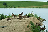
Our favorite camp site so far, Drew and I are at Chase State Fishing Lake,
near Cottonwood Falls, Kansas. We’re
right on the rocky banks of the lake, sharing space with a few families of Canadian geese. The weather here
is strange, though. The news says ’breezy’, meanwhile the winds gust up to 25 mph and higher. The air is almost never still,
but the delicious side effect of that is wonderfully comfortable days despite the summer heat.
June 8, 2009
Clearing out of Chase Lake sooner than expected, and somewhat regretfully. We’re operating the fridge on propane fumes,
and that breeze we we’re enjoying so much has taken a turn. Last night’s thunderstorm was far scarier than any Floridian
tropical storm we’ve ever seen. The rain pounded the roof, the winds rocked the Spaceship, and neither of us got very much sleep.
June 9, 2009
Passed through Hoisington, Kansas on the way to
Cheyenne Bottoms.
A sweet little town, still recovering from a 2001 tornado.
We’ll be picking up our provisions and mail there after a boondock alongside the nation’s largest interior marsh.
Faith is thrilled to the gills with all the visits we’ve had from the local bunnies.
June 15, 2009
Notes from Cheyenne Bottoms: home of what surely must be
Kansas’s largest tree. Our camp site is replete with bunnies and birds.
A raccoon supervises all of our food-related activities, and wonders why we won’t share. We’ve also learned how the cottonwood
trees get their name — their beautiful flurries of fluff are seed and pollen-bearing. We sneeze even as we ooh and aah over the
floating puff storms. The flat lands here extend into forever, roads disappear into watery mirages at the horizon. And the strange
Kansas weather continues. Are these storms unusual, out-of-the-ordinary, or just the norm on the plains? Who can know?
June 16, 2009
So we are now in Great Bend, Kansas, waiting for help with our leaky toilet. We found a shady RV park to while away the days, as
our appointment’s not until Thursday. Meanwhile, we’re scootering around town, exploring, stocking up on provisions, and
sweating-sweating-sweating. Kansas is HOT in June!
June 18, 2009
Got the toilet fixed today at Harper Camperland. They wanted to put in a new one, but Drew asked them to do their best with the
old one, since it’s a water-saver. He watched them do the work, so we can do it ourselves if there turns out to be a next time.
After a long, hot drive across endless fields of corn and wheat, tonight was supposed to be a pleasant and brief layover at
Scott Lake State Park, where we would recover from the repair bill, and just relax. Alas, a rude cottonwood tree flung itself
bodily at us — crashing into the tail of the RV as we were backing up, and crunching our poor scooter rack.
(That’s our story, and we’re sticking to it). Will search for a welder in town tomorrow.
June 19, 2009
We left the scooter at Scott Lake State Park this morning (thank you Glen Mills, Park Ranger), and drove today into
Scott City to get some help from Jerry’s Welding. Hooray Jerry! He fixed us up in a flash, for a downright reasonable price.
Then, with a de-crunched scooter rack, we were off in search of the much touted Monument Rocks, named one of the eight wonders
of Kansas. The High Plains extend here for as far as the eye can see. No towns, no houses — not even telephone poles along the road.
We pulled into the only building around for miles, the Keystone Gallery, to ask for directions, and we got treated to a gander
at gigantic fish and clam fossils, plus a very cool map of the sea that used to occupy Kansas 80 million or so years ago.
From there, we drove down a dusty, lonely dirt road deep into the remote prairie.
Holy chalk formations, Fossilman!
These ancient rocks just spring up from the middle of the plains — inexplicable, beautiful. Here also live the silliest
birds West of the Mississippi, cliff swallows, which are something like avian mud daubbers, they building little mud nests
on the sides of the rocks. We spent some time watching them as they left their nests on the hunt and came back with food for
their little ones, who we assume by the sounds of tiny peeping, were hungry and waiting inside their little adobe nests.
This is our last boondock in Kansas.
We have this place to ourselves tonight.
The sunset on the Plains here is magical.
June 20, 2009
We left Monument Rocks this morning, and drove through the remote
High Plains. Had an amazing drive
through Colorado, saw our first wild antelopes, as well as more wheat and corn than can actually exist in the time-space continuum. It was an overcast
and often rainy day, great for driving. We thought the weather was going to obscure our first view of the Front Range, but
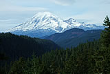
just like a gift from above, the clouds parted and the still-snowy Pikes Peak was revealed. Faith says she doesn’t know how
people can function in the shadow of a mountain like that. “I’d spend all my time awestruck, forgetting everything except
the Ineffable Bigness.” On a final note, Colorado Springs is expensive and not our speed. The plan: to get out of here and
into the wilderness.
June 24, 2009
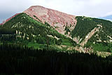
We’ve settled in to our new home for the week, a little meadow along Fourmile Creek in an area called The Crags.
It was a rough road, but the Spaceship held together. We’ve hiked a little bit of the trail that goes by here, and,
WOW the amazing colors of the rocks! Bright pink with marbled red and apricot, rounded by the weathering ages.
We’re in the Pike National Forest, at the base of Pike’s Peak. Our first 14er.
June 25, 2009
Colorado seems to be the ideal place for folks who like the mountains, but also need lots of civilization and very
little seclusion. The road that runs by our campsite is busy, and as soon as one of our neighbors leaves, someone
new pops up to take their place. At one point, more than 30 cars crowded around a nearby trailhead. As we prefer
to enjoy a little solitude with our wilderness, we’ve chosen the less-loved trail, where the
the pay-off is lovely,
if a little less dramatic. Whoever designed the trail did an amazing job, and we’ve still got plenty more to explore.
June 26, 2009
A bruising hailstorm ripped through the canyon today and knocked our generator, leaving an ice-white forest floor behind it.
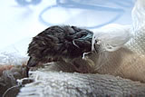
We hiked back to the red rocks after things dried up a bit, and we discovered an abandoned baby critter on the trail.
He was alone, wet from the recent rain, his little eyes still closed, and he was being attacked by ants.
We decided to interfere with the cycle of nature, rather than have to look ourselves in the mirror every day knowing
we abandoned the little guy to his fate. We scooped him up and brought him back to the RV, where we made him a little
food-storage-container home. We have some S.O.S. e-mails out to local wildlife rehabilitators.
June 27, 2009
Squeaky, as we’ve named him, didn’t want sugar water, milk, or turkey fat last night, but he did finally lap up about
a drop of sugar water this morning. We’ve been in search of help all day. The Forest Service camp host down the road
directed us to a nearby Mennonite Camp, where the nice people there had a heat lamp and a fresh box for him. We left
him in their care and wished him the very best on the next leg of his journey. (By the way, the theory is that he’s a
grasshopper mouse.)
June 30, 2009
We went to the Mueller State Park yesterday, near Divide, CO, planning to spend the night there and scooter back and
forth into town for provisions before moving on. Plans change.
Possibly because there’s no beach (and because the mountains are beautiful, of course), camping is big business out here.
In order to get the biggest slice of the pie possible, the park service advertises that camping overnight at Mueller costs $18.
When you arrive, however, they also want you to pay a “day use” fee on top of the camping fee. Just this, unto itself,
is deceptive, but we had nowhere else to go, and so we rolled our eyes and got ready to shell out the additional six bucks.
But that wasn’t enough for the park service. If we wanted to use our scooter to go back and forth into town, we’d have to
spend an additional six dollars for a day use pass for the scooter. By now, the money wasn’t the issue;
it was the principle of the thing. We left feeling ticked off and tired of Colorado’s outdoor tourism machine.
After the park, though, we got to follow up on an invitation from Z.G. Standing Bear, one of the kind souls who
emailed with us regarding the Squeaky ordeal. He operates the nation’s smallest federally-funded zoo.
And the best part? It’s a hedgehog zoo. Standing Bear was kind enough to invite us to his home and
introduce us to his bevy of bespined friends, all of whom were sleeping when we arrived. They were a
little resistant to the idea of waking up, but with a little coaxing from Standing Bear, they poked
their little noses out and snuffled sincerely.
From there, we traveled to Cripple Creek, which has been eaten by casinos. Thanks to the kindness of a
stranger were we able to locate the town’s only gas station - there’s not a chance we would have found
the place on our own. Just as we pulled in, the hail began to rip across the sky, so we hung out for a little while
and waited for it to pass. We continued on through the back roads of Teller and Park counties, the mountains
silhouetted against the moonlit sky. A beautiful drive...until...Dum-Dum-Dum... ...the greasy mud on the dirt
County Road 88 began to cake up on the tires, and the Spaceship began to careen between the ditches in the dark.
Drew began losing control of the vehicle just as we (literally) slid into BLM land. As if in answer to a prayer,
we were barely able to make it to a little turnout on the side of the road that seemed to be waiting just for us.
July 1, 2009
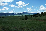
We are boondocked at our first BLM site, and it sure is a beautiful one. Pretty much smack-dab in the middle of Colorado,
between the Front Range and the Collegiate Peaks is a rolling expanse of woodlands and high prairie where we finally have
a little solitude. We went trekking last night up the grassy hills around Paris Creek, and took in the vista of the
surrounding area. This most certainly was a pleasant and unexpected stop. We’re still at the place we (literally) slid into
the other night.
July 2, 2009
Woke up this morning on a hill across the valley from the Waugh Mountains. This is a pretty remote part of Colorado, peaceful
and quiet all morning. Upon leaving, we thought that County Road 2 down in the valley was a paved road, based on the map in
the Gazetteer . It was in fact another dirt road. That’s fine, we had the gas, so we drove and drove and drove on this
scenic-but-remote dirtway until we came out of the mountains and into Salida.
Had a brief stop here, in hopes of finding a
print shop where we could take care of some business. But no luck. Moved on to Gunnison.
At Monarch Pass
we crossed the
Continental Divide, and all the creeks began flowing westward. Got in town after dark. Spent the night in a Wal-Mart parking lot. (Haven’t done that in a while!)
July 3, 2009
Gunnison has the best health food store and the best bookstore
we’ve seen in ages. Getting provisions in this town was a breeze,
despite the pre-holiday busy-ness. Laundry, groceries, fuel, water, supplies, stuff — all done, ready to venture into the woods.
But the Gazetteer led us astray trying to get to the wilderness west of Gunnison.
So we backtracked through BLM lands south of town,
and found a nice turn out in the sagebrush as the moon was rising.
July 4, 2009
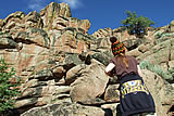
This morning, we decided to stop for a hike on Bambi’s trail. (No, Faith didn’t make up that name.) Did some
rock climbing,
and enjoyed the view of the mountains in the distance. Back down in Gunnison, we spent a little time enjoying the
Book Worm bookstore and strolling through the Gunnison Farmer’s Market. Drew tried a little kombucha tea and Faith
picked up some freshly picked cilantro. A great start to what was about to become an urky day.
From Gunnison, we drove out to Crested Butte to check out the town and the National Forest beyond it. We were all
loaded up for a 9-day boondock and excited we would finally be entering the heart of what Colorado is known for — it’s stunning mountains. Our reality check occured
as we entered town. The population of Crested Butte was actively hostile, drunk in the
streets, and one guy, presumably dispatched by the Chamber of Commerce, yelled “Go back to your campground!” At the gas station, a charming lady on a bike yelled for
“Idiot!” as loud as she could. We presume this clarion call was directed at either her husband or her children. Up the road from town, before you can get to the tantilizing peaks ahead,
you have to pass through Mount Crested Butte. This is a collection of 1970s ill-suited homes and condos that litter the hillside in the guise of a resort. From this point on, the local folk have a lockdown on the
the amazing wilderness beyond. The forest road was clogged in
a parade of BMWs and Lexus SUVs trying to squeeze their way from one end to another. In a forest where dispersed camping is supposedly permitted, every potential site is
marked No Camping. After moving through traffic that rivals downtown Colorado Springs, the one campground we did find contained a whopping five sites, all taken of course.
Simply put, the pressure of so many people here has clearly taken
its toll. Signs put up by the USFS explain that campers would “ruin” these sensitive lands if they allowed more sites. (Read: You have to pay for accomodations at the local resort).
This might as
well have been a parking lot winding through the forest.
Rattled but still undaunted, we decided to continue on to
another part of the forest, but had to turn around (navigating an 18-point turn) and head back through Crested Butte.
Arriving in town, we realized this too was a mistake — a Paris-Hilton-wannabe trying to
hitch a ride at the bus stop actually gave us the bird and cursed when we wouldn't stop. A situation made more angering by the fact that we couldn't stop — all the traffic was honking behind us!
I don’t know where these lame people come from, or why they all moved to Colorado. Now with increasing anxiety, we drove through town trying to find a road out. Any road out. Could we ever get out of here?
We did find a road that wound west, and hoped this route would lead to greener pastures, so to speak.
But even after an hour of driving deeper into the mountains there were no spots to boondock, and as for solitude, there was none. Just more cars. More trucks. More people.
To Coloradans, the mountains must be like the beach in Florida: they go there to recreate and socialize. Combine the constant presence of people with the almost universal
rudeness of those same people ... I’ll just say we are ready to get the heck out of this state. Crested Butte is proof positive that not every beautiful place is worth
visiting. Words can’t express. Seriously.
We pulled over and dumped the water in our tanks. No sense driving around heavy, we weren’t camping any time soon. We pressed on for a few hours, hoping to gain some distance.
The mountains turned to desert and we were once again alone. Quiet. At peace. As the sun was setting in the canyons. We drove through a coal mining town,
passing by the
great mountains of black, stony fuel. From there, we made our way into Hotchkiss, where the good folks at the City Market
directed us to a nearby fairgrounds. We parked under the stars and caught our breath.
July 5, 2009
Little Hotchkiss is renewing our faith that
not every place in this state is overrun with the poopy people.
Spent some time at the Creamery Art Gallery and saw some world-class local art. In the park,
we watched a man, guitar in hand, serenading is wife of, oh, probably 40 or so years. Very sweet.
July 6, 2009
Drew did the uber-oil change, lubricating points and many other tasks reserved for the mechanically-literate. Left
Hotchkiss at 4:30pm, destination uncertain. We drove through the Demaree Canyon, west of
Grand Junction, in search of
a campsite. A nearly full moon lit the way through the Book Cliffs. We were both ug-tired by the time we found a place
tucked in a canyon crevice to spend the night.
July 7, 2009
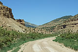
This was an epic sort of day. We woke up on BLM land (sort of...oops, sorry, land owner) north of the Demaree Canyon
wilderness with the intention of crossing Baxter Pass and traveling out of Colorado and into Utah. The paved road turned
into a gravel road turned dirt road, which then turned into a rough-and-tumble jeep trail. So much for being a
AAA map-labeled County Highway! (Hwy 201 to be exact.) There were some rough spots to the Pass, but all was basically
well until we saw The Boulder in the road. We stopped the Spaceship and Drew got out to investigate. Yes, the rock was
probably passable, but just beyond it, the road had given way where another boulder had pounded through it. What was
left of the road was crumbling in bits - before our eyes - into the abyss below. We stared into the gaping maw, and
decided not to tempt fate. Not a minute after we made our decision to turn around, the cliff above us started crumbling,
too, rock flakes snowing down upon us. We theorized that Someone was telling us to get the heck out of there. So we got.
Turning the 23-foot Spaceship around on what was probably a 25-foot wide ledge was no tea party.
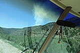
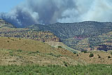
On the way back down we caught sight of a forest fire that had recently started, which not only threatened us, but also
threatened a natural gas pipeline that ran the length of our exit. With only one way out, we made the slow crawl back down
the way we’d come. The fire spread. Smoke billowed into the sky, turning from white to black and grew denser as we drove.
Spooky stuff.
We We made it back to the paved road just as a TV crew appeared.
Not long after we emerged from Danger Gulch, we saw a gigantic
fifth-wheel RV parked, its driver hoping to chat with us. He asked if we’d made it through the Pass. We told him that, no,
after a few hours driving in, we’d had to give it up and head on back. Let me tell you, if we couldn’t make it, this guy
sure couldn’t. Our theory is that the same Someone who helped us out on the Pass sent us to turn this guy around before he
got himself into some trouble he couldn’t recover from.
Onward we drove, through Loma, back on paved roads once more. But paved doesn’t necessarily mean comfortable. After long
spates of uphill driving, the Spaceship went into distress, and we had to give our baby a couple breaks on the way up. We
even dumped some water to reduce our weight. We were, however, fortunate to get out of there before the earthquakes began.
Finally, with brakes so hot they screamed and stank, we found ourselves on the road to more BLM land. A place to spend the night!
As we drove the highway looking for a promising spot, we saw something we’ve been questing for years. (Truly, years.) WE SAW A BEAR!!! He was black and caramel and cream colored and his bear butt
(also, his bare butt, one supposes) jiggled as he made his way up a nearby hillside. Our noisy breaks spooked him and he took off, but we got a good look at him, all the same.
Less than a mile later, a coyote crossed our path. And shortly after we found our campsite down a BLM dirt road, we heard the
whinny of one of the local wild horses. We’re in critter territory now, to be sure. A quiet night to catch up on some rest.
July 8, 2009
We are in hills that have no name. Not on the maps anyway. We’re halfway between Loma and Rangely, on a dirt road east of
Highway 139. Apparently, we are deep in wild mustang country, somewhere south of the Douglas Wild Horse Management Area.
We heard one last night — perhaps a whinny of rebellion! Apparently the government hasn’t removed them all.
July 9, 2009
Moved the Spaceship down the road a bit. Today we are boondocked in the Rope Canyon. There is a nice animal trail that we
hike at night. The stars reach into infinity.
July 10, 2009
Stopped in at the little museum in Rangely. This town has the coolest town logo — sort of a happy space alien. Made our way
through the oil and gas fields near Dinosaur, and climbed into Utah. After stocking up on supplies in Vernal, we got some
maps at the Ashley National Forest ranger station and found a nice little turn-out on a BLM road in the Buckhorn Canyon area.
July 11, 2009
Lovely sunset hike up the rocks of Buckhorn Canyon.
July 12, 2009
A beautiful drive through Ashley National Forest and Flaming Gorge. Had dinner at the ranger station in Manila while
the rain passed. Drew walked the town a little. The scooter got a much needed bath at the gas station. And then — hooray —
we made it into Wyoming!
July 13, 2009
We drove through Wyoming along a scenic dirt road that paralleled a winding creek which flowed through a meadow in the
shadow of the range. After that, attempted to find a boondock spot in the Uinta Mountains near the High Uintas Wilderness
on the Utah side of the border. Did see the Hole in the Rock on our way to Hoop Lake, but by time we got to the lake, it was dark,
and all the good sites had been taken. So we backed out, and tried to find a spot among the sage on the Wyoming-side BLM land.
No luck there, either, so onward to Lyman where we found a city park that allows overnight parking. Thank you to the anonymous
family in Lyman who directed us the park. They were the only people on the road at midnight in this little town.
July 14, 2009
Stunning view of the Uinta Mountains as we woke up this morning in Lyman.
Picked up our mail and did some laundry back in
Mountain View. Unfortunate discovery: we
drove from Lyman to Mountain View with the satellite up! Thankfully, no damage.
Back on the road. The Spaceship is bucking like Drew’s old Bronco used to. Never did find out what caused the problem way
back then, so we’re a little concerned about how to fix this. Passed through the rolling sage hills through Uinta County
up to Kemmerer. In town, we saw the “mother store” for J.C. Penny, which opened in 1902.
Then, more bucking and stalling
through the arid canyonlands heading west of town. Stopped in Cokeville, Wyoming, and found a little city park that allows
overnight parking. We set up our spot, and listened to the passing trains.
July 15, 2009
Busy morning under the cottonwoods at the city park in Cokeville, Wyoming ... all the kids in town gathered outside the RV for
VBS. There’s a fun general store in town (called The Store), and got our fill of Western Family-brand supplies. Faith traded
some of her old books for new ones at the Library Friends’ sale, and also printed the first manuscript of her novel
(very exciting). Drew likes the trains that roll through town. We can see Idaho over the ridge to the west.
July 16, 2009
Two-night limit in Cokeville, so we move on. Drew kinda likes it here, but we’re looking forward to the next adventure.
Really hot today. The Spaceship is having a hard time making it up hills without stalling. Crossed the Idaho border briefly,
and then back into Wyoming, over the pass into Star Valley.
Picked up some supplies in Afton. After all the bucking and sputtering,
the Spaceship finally died on the road north of Thayne. We let it sit for awhile, and Drew got it started again, only to have it
throw up its hands once more around Alpine.
We found a boondock spot where we could stay for a few days and figure out what the
problem is, but the vehicle kept stalling out on the dirt roads, so we gave up and found a paved place to park at the national
forest border.
July 17, 2009
With a little Help From Above, we were able to fix our engine back in Chanute, so we were hoping for a similar Assist here in
Thayne.
Found a NAPA auto parts store, and Drew got up to his elbows in the engine. (Special thanks to Complete
Auto Parts in
St. Pete who walked Drew through the process by phone.) Despite his best efforts, however, Drew stripped the sensitive aluminum
threading on the carburetor intake where the filter meets the gas line. Now we might have to replace the entire carburetor!
Fortunately, this auto parts store also has a friendly mechanic next door at Star
Valley Ski Doo. Drew worked with him to try
to triage the damage, and we now have a carburetor thread repair kit on order which should be here tomorrow. Walked around
Thayne after dinner. The beautiful Salt River Range
rises to the east of town, and the rolling hills of the Webster Range
flank the west, where the sun sets in Idaho. The good folks at NAPA let us stay in their parking lot tonight.
July 18, 2009
Well, the carburetor thread kit didn’t work. Drew and our new mechanic friend spent the morning working on the RV, and it
appears the only solution now a new or rebuilt carburetor. So after making some phone calls around Star Valley, our
(now beloved) mechanic went out during his lunch break to find us the used parts we need to rebuild it. What a great guy!
The moment of truth came when we put the frankenstein carburetor in, and turned the key. It works! It runs a bit rough, but
so what? It runs! We’ll spend another night here in the dirt lot of NAPA under the stars of Thayne.
July 23, 2009
We’re coming out of the woods today. We’ve been in the hills above Tin Cup Creek in the Caribou National Forest.
July 24, 2009
Refrigerator needed a little help today, so we scootered into Smoot to get some ice. We’re camped out in a
Wyoming wildflower
meadow along Cottonwood Creek, east of Smoot.
July 27, 2009
Grocery run into Afton, then up to Thayne. Drew spent some time in the Thayne library uploading the real estate website
(over 14,616 html files - a little too much for the Datastorm). Special thanks to the librarian at the Thayne library for
staying a little late after closing. Had a beautiful drive into Idaho around the Palisades Reservoir and through Swan Valley.
July 30, 2009
We are camped in the lava fields west of Rexburg.
Special thanks to the Rexburg library for letting us upload the rest of the real estate
website on their computers. We saw our first movie on the road in Idaho Falls, and stayed a night at the Mountain River Ranch
to shore power our batteries.
August 1, 2009
We drove through the Idaho National Engineering laboratory today. We’ll be eating lots of miso soup.
August 3, 2009
Mackay (pronounced ’Mackie’), Idaho,
is nestled in the valley between two mountain ranges. To the east is the Lost River Range,
a wall of rock that includes Borah Peak, the state’s tallest mountain.
To the west are the White Knob Mountains, a verdant expanse
of hills that breaks into jagged peaks at its core. Mackay is a town of 500 or so people, all of them friendly. We stayed in the
Mackay Tourist Parkwhich overlooks the rodeo arena. Camping in the park is free, and Peggy at City Hall said we could stay as
long as we wanted. On Saturday we strolled through the booths at the little Mackay art festival, and on Sunday rode west of town
up to the Mackay Mine for an abbreviated tour of the now-defunct mine — abbreviated because our 49cc scooter can either carry two
people or climb steep grades, but not both. The kids in town seemed to like our scooter, and one even offered to buy it. In fact,
it seems everybody around here gets around town by small engine. Travel by ATV around town is so common in Mackay that two
brand-newlyweds left their ceremony on a four-wheeler, aluminum cans tied to the back.
August 8, 2009
Enjoying a nice quiet stay in North Fork, Idaho.
In the territory of an owl; we often hear it screeching. One evening, it landed
on the satellite dish and jarred the whole RVwith its weight. On another, sadder topic it seems that all of our photos from our
Borah Peak hike last week have been erased from the computer, save for one. Drew is very disappointed. There were some good ones.
Ready to continue our journey on up into Montana, but first, we’re heading back down to Stanley to get in some wilderness hiking
in the Sawtooths before the summer ends.
August 17, 2009
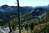
Today we wrapped up our boondock in the Sawtooth National Recreation Area near
Stanley. Special thanks to Sherian Allen who met
with us at Alturas Lake, where we spent the day among the lodgepole pines. We’ve had a healing 10 days in the heart of Idaho.
Other good stuff: we saw a badger for the first time, and of course, thousands of ground squirrels, tree squirrels, and chipmunks.
They popped up in the morning in and around the clearcut we called home, an early-morning entertainment for faith.The hike in the
Sawtooth Wilderness was inspiring. Our after-dinner walks around Iron Creek were lovely, too; it hasn’t been since Istachatta that
we’ve heard the lowing of cattle. There is another owl here. S/he screeches at us at night. Our little boondock on top of the world
has been an unexpected but pleasant detour.
August 18, 2009
We woke up in the Grandjean area of the Sawtooths, and made our way down the Payette River to Garden Valley. It was nice to see
Cascade again. We got to McCall before the health food store and Paul’s grocery closed. Spending the night at a trailhead in the
Payette National Forest.
August 19, 2009
Visited the Monastery of St. Gertrude in Cottonwood, and had some quiet time in their Chapel.
The Camas Prairie around here is
very pretty. The owner of The Depot in Grangeville is letting us stay in his parking lot tonight. (Thank you!) We strolled downtown,
and saw the Tolo Lake mammoth at Eimers Park.
August 26, 2009
We rolled into Moscow last Thursday, the same week the U of Idaho’s students returned for fall semester. Aside from the
tense freshman vibe in the air, however, all has been pretty serene. We’re camped out at Robinson Park
(once the home of Robinson Lake), and are using the scooter for errands and general cruising to and from town.
There are more hiking opportunities than we expected. Here, at the park, we’ve enjoyed our evening walks along a short trail,
where we’ve communed with the a pair of now-you-see-them-now-you-don’t owls. Maybe they followed us from North Fork! We’ve gotten
a look at them this time, though, (with binoculars) and think they are probably great-horned.
We’ve also hiked a mountain bike trail
in the giant cedars of Moscow Mountain.
Our biggest sources of strife have been these: first, the birds (not sure what kind they are, but they act like the
cliff swallows
we encountered in Kansas,) have targeted Drew, who was made victim to a round of serious dive-bombing when he ventured too far from
our vehicle. Second, is a more ’human’ difficulty. We, personally, have developed a relationship of tolerance with the local yellow
jackets. They fly into our home, we gently shoo them out. They land on us, we wait until they fly away. Pretty much, we’d decided
that their reputation for aggression was unearned. Then our neighbors showed up with fly swatters, bug spray and yellow-jacket traps.
Now, our buggy friends are agitated and appear to be aggressive with each other, if not with us. Why the change? One of our theories
— their hive attrition rate, thanks to the very effective yellow jacket traps, etc., has caused an imbalance in their social
structure. Hence the upset. So, is it the chicken, or is it the egg? Are they mean to humans, or do humans make them mean?
Life is complex.
September 1, 2009
We’ve added a new section to the site, where we’re going to list all the campgrounds we’ve stayed at. We have found so many
good camp sites ourselves, as well as great the campsites we’ve found on the internet, that we want to pay it forward.
So, if the list we’re building helps other people as much as we’ve also benefited, then we’d be happy.
September 3, 2009
We found a nice little park on the way to Powell, and stayed here last night in tiny Cavendish. Tonight we should be in the
Bitterroots. :)
September 4, 2009
We rolled into Powell Ranger Station in the Clearwater National Forest yesterday. After a consult with Connie at the Forest
Service office, we stopped in at the Lochsa Lodgefor gas and chat. Faith was excited to find a paperback exchange at the
General Store where she picked up a new book to read. (Woohoo!)
September 6, 2009
Well, here we are, five months after we set off, at one of our favorite places in the world. We’re settled in at our campsite
on the edge of the Selway-Bitterroot
Wilderness Here, on the tallest peak near our boondock spot, we’ve found the winter home
of every
ladybug in a hundred mile radius!
September 9, 2009
On Tuesday night we met a pair of friendly German tourists who shared our campfire. Another unexpected guest, a dear of a deer
has visited us more than once in the cool, dusky evening hours. We’ve found a nearby patch of wild huckleberries that have supplied us with fresh fruit for Drew’s morning cereal.
September 12, 2009
We’ve hiked up to the tops of jagged mountains, down to deep lakes hugged by trees on all sides, and all around cliffs and canyons
— in search of the elusive pine chicken.
Buh-gok! It’s also been a big week for forest fires — we’ve seen at least six of them
from the top of the mountain — one big enough to actually view the flames (and the intrepid forest service helicopterists)
through binoculars.
September 13, 2009
It’s been our longest boondock so far — ten days in all. Each morning we wake up to a view of the
Bitterroot Mountains as
seen from our spot in the
Clearwater Mountains If we didn’t need provisions (our kingdom for some propane!) we’d stay another ten.
September 14, 2009
Wow! It was easier going up than coming down. Coming out of the wilderness yesterday, we lost our brakes once (thank you RV fairies
for bringing them back), and had to stop several times to cool down the engine and brakes. During our five-hour descent, Drew had
to engage the emergency brake to slow us down. The first hubcap exploded (literally) about 2 miles from the bottom, and we lost the
second one when we got to U.S. 12. Blew one tire on the rear duallies and bent the side rail on the passenger side. Had to scooter
the rest of the way to Powell. Thanks to Geico emergency roadside service and the Lochsa Lodge for letting us use their phone.
So tonight we’re back in “civilization” (that being the ranger station — the nearest town is 52 miles away). We’ll head into
Lolo tomorrow to find a replacement tire and restock supplies. Drew was able to fix the bent side rail this morning. At least
we made it down, and we still have a home. Going up was so smooth and easy ...
September 16, 2009
All is well and back to normal. We were able to find the exact tire in Missoula, so that has been fixed. Plus, as a bonus,
Mike, the really cool mechanic Tire-Rama, rethreaded our bum lug nut bolt, so it’s even better now that when we left our
home in Istachatta. The bent side rail is fine now. The brakes are better than ever. We’re all stocked up and having the
first day of our new boondock on some old Plum Creek land intermingled in the District. We’ve had a peaceful morning, and
now it is time to rest. :)
September 18, 2009
Camped out here near the head of Dead End Road, at a place they call Crime Saddle. Who woulda thunk that a spot with such an
unappealing name would offer such an amazing view
September 23, 2009
We’re not too far from a junction with a steep road where folks come and go with horse trailers. We feel for the horses —
it’s noisy enough inside those trailers, even when you’re not driving one of the rockiest, roughest roads in the national forest.
Not far from here, we’ve found a stand of
old growth cedars, not to mention moose munching their way toward winter, and the
occasional bugling (if invisible) elk.
September 25, 2009
Went down to the ranger station today, where we picked up and sent out our mail, and chatted with the locals. Trying to figure
out a way to stay here for ever and ever.
September 28, 2009
Scootered to the end of Dead End Road. Saw the elusive pika, who makes a sound sort of like a rubber duck. Too cute for words.
Seriously. Ineffable cuteness.
September 30, 2009
We had our first snow of the season today, up at Lolo Pass.. Magical. A little other-worldly.
October 3, 2009
Camped out at White Sands Campground. It was our intention to return to Dead End Road, but the Indian Summer is definitely over.
When we drove up there yesterday the snow was blowing, and downed trees blocked the road. We went looking for alternative spots
on Beaver Ridge Road this morning, but none of them quite worked out. Besides, the winds were brutal. So we’re back at the campground.
We’ll enjoy the turn of the seasons in a nice, safe place. :-)
October 8, 2009
Snow is frozen to the solar panels this morning, but our Spaceship heater is working just fine. Nice and cozy inside. We’ve been
having campfires at night at our spot along the Lochsa River.
October 12, 2009
It would appear that our stay at Powell has come to an end. The temperature isn’t reaching above freezing, even in the daytime.
The river is frozen along the edges, and our water containers outside are frozen solid. We’re not sure know if our holding tanks
have frozen, but if they have, there could be some permanent damage for which we are not prepared. So, we said goodbye to everyone
this afternoon at Powell, and we made our way down the Lochsa toward Lewiston in the night, past the warm glow of Kooskia and down
into the lower elevations of the Clearwater River. There are many, many trucks here tonight, and though it is still in the 30s,
at least our tanks can now begin to thaw.
October 14, 2009
We have Robinson Park to ourselves. It is cloudy and cold, and very different from our warm, sunny stay only weeks ago. We
have decided what to do next. Looks like we’re going to head into Washington. We leave tomorrow.
October 19, 2009
OK. It seems Washington is not the place to be this winter. We’ve Traveled to the Olympic Peninsula area, west of Seattle,
and every single day since we’ve arrived has been a slow, persistent drizzle. Even in the rain shadow around Sequim, a place
that (supposedly) receives only as much rain as a desert, the rain fell and fell. So now, instead of snow and ice threatening
our home, we have the growing aroma of mildew and mold blossoming in our carpets and walls. Looks like we’re going to have to
head South.
October 24, 2009
Last stocking of supplies in Moscow before the big cross-continental push. A trip to Rosauer’s, the Co-op, and a little laundry
before the drive. Friends Rob and Courtney came to visit, and Courtney leaned how to make fortune-tellers. We had a visit from a
moose at Robinson Park yesterday. A harsh cold-front is heading this way, and unless we want to be stuck here in an unpleasant way, we’re going to have to go.
Back to the sultry South!
October 27, 2009
We’re riding the edge of the cold front like a surfer riding a tsunami wave. Today we traversed the heart of Montana, 55 mile
per hour winds (really, not an exaggeration) ripped across the highway. Somehow we were able to make it over the Continental Divide,
but we lost the refrigerator vent door on the exterior of the RV. Then, the highway just beyond Livingston was closed to trucks,
so after circling the town in the gusts, we found an RV park for the night. Just in time. Sstill more damage was to befall us,
however, as the door was ripped open by the wind, tearing it off the hinges (literally). We’ll make a final damage report tomorrow.
October 29, 2009
The snow caught up with us at 4:30am at a rest area in Sheridan, Wyoming. Drew fixed as much of the damage from Hurricane Montana
yesterday as he could, so we were ready to roll after a brief rest. Made it all the way through Wyoming, but the wind shield wipers
are done — severe damage from the ice. We made it to the leading front of the weather, and into the rain that rides ahead of the
snow squall. A brief pause in Lewellen, Nebraska, but the snow has caught up with us. So, now we keep going. And going.
October 30, 2009
We drove out of that cold front yesterday, and into Kansas, where the snow turned to rain (once again). Thought we were out of
the worst of it, but there was one final winter hurrah in store. This morning in Oberlin we were treated to a fluffy, white farewell.
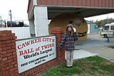
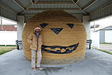
The winds were still strong, so we took roads that put the gales in our sails, and that steered us right into little Cawker City,
home of the world’s largest ball of twine. We couldn’t resist. Had to stop. It is our opinion, however, that it is more accurately
the world’s largest plop of twine, rather than an actual ball.
October 31, 2009
We spent last night at the same Wal-Mart in McPherson, Kansas, as we did just a few months ago.
Drew changed the oil in the generator, so it’s chugging along more happily.
The heater is sending up its SOS clicking sound more and more often now, and is on the verge of giving up the ghost.
It’s as if the Spaceship is breaking up upon re-entry.
Tonight, on Halloween night, we are in the Arbuckle Mountains (hills, truly) and have circled up for the night at a
Scenic View rest area. We’re about three days away from Florida, so we’re going to just push on through from here.
It’s ground we’ve already covered, so this is probably a good place to sign off. Thanks to all who have followed us
as we ventured across the continent, as we posted these thoughts for you to share, and for your words of support
and encouragement in return. Opportunities like this come around only once in a lifetime.
Gas prices are starting to go back up, and it will probably be a long time before we see $1.89 a gallon again.
So, as we’re winding down our adventure, and in reflecting upon what we learned,
I guess the biggest thing to take from all this is ... well, this:
You know that idea you’ve been thinking about? The one that you keep saying to yourself,
“Someday”? Begin it today. Because as Annie Dillard says, “How we spend our days is, of course, how we spend our lives.”